


eCOP - SDR
Description of eCOP - SDR
eCOP, developed for emergency response, is an application that utilizes local government data to enhance 9-1-1 call mapping and emergency location services. This app is particularly useful for first responders and emergency management professionals who rely on accurate and real-time information to coordinate their efforts during emergencies. Designed for the Android platform, users can easily download eCOP to their devices for immediate access to critical information.
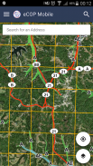
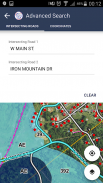
The primary function of eCOP is to provide address, coordinate, and intersection searches. By integrating map data maintained by local 9-1-1 systems, the app enables users to locate specific addresses or coordinates quickly. The application leverages the device’s GPS capabilities, allowing users to track their location in real-time on the map. This feature is particularly beneficial during emergencies when precise location information is essential for effective response measures.
In addition to location tracking, eCOP offers a user-friendly interface that simplifies the process of searching for locations. Users can input addresses or coordinates to retrieve detailed mapping information, which is vital for planning routes and ensuring timely responses to incidents. The app’s design aims to facilitate efficient navigation and information retrieval, making it easier for emergency personnel to access necessary data when every second counts.
The application’s ability to function seamlessly with local government data enhances its reliability and accuracy. Since the information is regularly updated and maintained for the local 9-1-1 system, users can trust that they are receiving the most current data available. This is crucial for emergency management, where outdated or inaccurate information can lead to significant delays and complications during critical situations.
Another aspect of eCOP is its focus on enhancing situational awareness. The app provides users with relevant information about their surroundings, which is essential when responding to emergencies. By offering detailed mapping and location data, eCOP helps emergency responders understand the context of their environment, allowing for better decision-making during operations.
The GPS tracking feature not only aids in navigation but also plays a critical role in incident management. First responders can share their locations with colleagues, facilitating coordination and communication during emergencies. This feature is especially important in situations where multiple units are deployed, as it ensures that all parties are aware of each other's locations and can respond effectively to evolving scenarios.
eCOP also supports intersection searches, which are significant for navigating urban environments. By allowing users to search for specific intersections, the app helps responders quickly identify key locations and plan their routes accordingly. This feature can be particularly advantageous in densely populated areas where navigating to a precise location can be challenging due to traffic and other obstacles.
The app's emphasis on real-time data access is a significant advantage for users. During emergencies, having immediate access to accurate information can make a substantial difference in response times. eCOP’s design reflects this necessity, providing a straightforward way for users to retrieve information quickly without unnecessary complications.
Furthermore, eCOP integrates various tools and functions to enhance its usability. Users can customize settings to suit their preferences, ensuring that the app aligns with their specific needs. This adaptability makes it a valuable tool for a wide range of users, including emergency management professionals, public safety officials, and volunteers.
The application’s development reflects a commitment to improving emergency response capabilities. By utilizing advanced technology and data integration, eCOP aims to empower users with the tools needed to respond effectively to emergencies. This focus on enhancing operational efficiency and situational awareness is a core objective of the app.
As users download eCOP, they gain access to a platform designed to streamline emergency response efforts. The combination of accurate mapping data, real-time GPS tracking, and user-friendly interfaces positions eCOP as a vital resource for those involved in emergency management. The app serves not only as a mapping tool but also as a comprehensive system for coordinating responses and improving communication among first responders.
Incorporating features that support both individual and team-based operations, eCOP facilitates collaboration during emergencies. This collaborative aspect is crucial in ensuring that all responders are working towards a common goal of public safety and efficient crisis management.
The emphasis on accurate, real-time information is instrumental in enhancing the effectiveness of emergency responses. eCOP stands out as a reliable application that addresses the critical needs of emergency personnel, enabling them to navigate challenges more effectively and serve their communities with greater efficiency.
eCOP - SDR - Version 1.1.6
(10-10-2020)eCOP - SDR - APK Information
APK Version: 1.1.6Package: com.a39dn.ecopLatest Version of eCOP - SDR
Other versions


Apps in the same category


